The city history dates from 1488 when the first reference to Bandung exists. But from ancient archeological finds, we know the city was home to Australopithecus, Java Man These people lived on the banks of the Cikapundung in north Bandung, and on the shores of the Great Lake of Bandung. Flint artifacts can still be found in the Upper Dago area and the Geological Museum has displays and fragments of skeletal remains and artifacts.

Bandung City Square (Alun Alun) in 1939

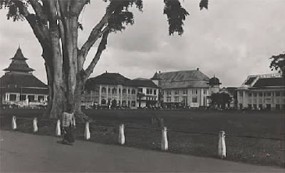
Bandung City Square (Alun- Alun) 2008

Bandung City Square (Alun- Alun) 2008
The Sundanese were a pastoral people farming the fertile regions of Bandung. They developed a lively oral tradition which includes the still practiced Wayang Golek puppet theater, and many musical forms. "There is a city called Bandung, comprising 25 to 30 houses," wrote Julia de Silva in the 1614th
The achievements of European adventurers to try their luck in the fertile and prosperous Bandung area, led eventually to 1786 when a road was built connecting Jakarta, Bogor, Cianjur and Bandung. This flow was increased in 1809 when Louis Napoleon, the ruler of the Netherlands, ordered Governor General HW Daendels, to increase Defenses in Java against English. The vision was a chain of military defense units and a supply road between Batavia and Cirebon. But this coastal area was marsh and swamp, and it was easier to construct the road further south, across the highlands Priangan.

Asia Afrika Street 1935

Asia Afrika at Nigth 2009

Asia Afrika at Nigth 2009
The post Grote (Great Post Road) was built 11 miles north of the then capital of Bandung. With his usual terseness, Daendels ordered the capital to be relocated to the road. Bupati Wiranatakusumah II chose a site south of the road on the western bank of the Cikapundung, near a pair of holy wells, Sumur Bandung, supposedly protected by the ancient goddess Nyi Kentring Manik. On this site he built his Dalem (palace) and the Alun-Alun (city square). Following traditional orientations, Mesjid Agung (Grand Mosque) was placed on the western side, and the public market on the east. His residence and Pendopo (meeting place) was on the south facing the mystical mountain of Tangkuban Perahu. Thus was The Flower City born.


Grand Mosque in 1880 , 1920, 2008
Around the middle of the l9th Century, South American cinchona (quinine), Assam tea, and coffee was introduced to the highlands. By the end of the century Priangan was registered as the most prosperous plantation area of the province. In 1880 the rail line connecting Jakarta and Bandung was completed, and promised a 3 hour trip from the blistering in the capital Jakarta to Bandung.
With this life changed in Bandung, hotels, cafes, shops sprouted up to serve the planters who either came down from their highland plantations or up from the capital to Frolic in Bandung. The Concordia Society was formed and with its large ballroom was the social magnet for weekend activities in the city. The Preanger Hotel and the Savoy Homann were the hotels of choice. The Braga became the promenade, lined with exclusive shops Europeans.


Braga street in 1920 , 1937
With the railroad, light industry flourished. Once raw plantation crops were sent directly to Jakarta for shipment to Europe, now primary processing could be done efficiently in Bandung. The Chinese who had never lived in Bandung in any number came to help run the facilities and vendor machines and services to the new industries. Chinatown dates from this period.
In the first years of the present century, Pax Neerlandica was proclaimed, resulting in the passing of military government to a civilian one. With this came the policy of Decentralization to lighten the administrative burden of the central government. And so Bandung became a municipality in 1906.
This turn of events left a great impact on the city. City Hall was built at the north end of Braga to accommodate the new government, separate from the original native system This was soon followed by a larger scale development when the military headquarters was moved from Batavia to Bandung around the 1920th The chosen site was east of City Hall, and consisted of a residence for the Commander in Chief, offices, barracks and military housing.
By the early 20's the need for skilled professionals drove the establishment of the technical high school that was sponsored by the citizens of Bandung. At the same time the plan to move the capital of the Netherlands Indies from Batavia to Bandung was already mature, the city was to be extended to the north. The capital district was placed in the northeast, an area that had formerly been rice fields, and a grand avenue was planned to run for about 2.5 kilometers facing the fabled Tangkuban Perahu volcano with Gedung Sate at the south end, and a colossal monument at the other. on both sides of this grand boulevard buildings would house the various offices of the massive colonial government.
Along the east bank of the Cikapundung River amidst natural scenery was the campus of the Technische Hooge School, dormitories and staff housing. The old campus buildings and its original landscaping reflect the genius of its architect Henri MacLaine Pont. The southwestern section was reserved for the municipal hospital and the Pasteur Institute, in the neighborhood of the old factory quinine. These developments were carefully planned down to the architectural and maintenance details. These years shortly before World War II were the golden ones in Bandung and those alluded to today as Bandung Tempo Doeloe.

This is the landmark of ITB campus. The architect of this building is Ir. Mac Laine Pont (1920). This building is the combination between Indonesian traditional architecture style with modern western construction technique.
The war years did little to change the city of Bandung, but in 1946, facing the return of the Colonial Dutch to Indonesia, citizens chose to burn down their beloved Bandung in what has become known as Bandung Lautan Api, Bandung Ocean of Fire. Citizens FLED to the southern hills and overlooking the "ocean of flames" penned "Halo Halo Bandung," the anthem promising their return. Political Unrest colored the early years of Independence and consequently people Flocked to Bandung where safety was. The population skyrocketed from 230,000 in 1940 to 1 million by the 1961st Economic prosperity following the oil boom in the 70's pushed this further so that by 1990 there were 2 million inhabitants.
Present day Bandung is thriving. As home to more than 35 schools of higher education, there is a vibrant collegiate atmosphere. The excellent fine arts offerings have produced an artist colony of great repute and excitement. The textile industry is the largest in the country and contributes to a vigorous business climate.
In 1987 the city extended its administrative boundaries toward a Greater Bandung Plan (Bandung Raya) Plans for the city include higher concentrations of development outside the current city center, in an attempt to dilute some of the population density in the old core. These days Bandung Raya is still years ahead, yet the land has suffered deeply. Commercial activities run amok, God only knows who can take control. The city core is practically Uprooted, old faces are torn down, lot sizes regrouped, and what was idyllic residence is now bustling chain supermarkets and rich banks.
Parijs Van Java on the air
The view of Bandung in 1920's - 1930's


This is the view of the old Grand Hotel Homann and surroundings. Hotel Homann was founded around 1870 on the Groote Postweg (now Asia Africa Street) as a simple hotel, but grew to be the most popular hotel of Bandung. Many famous people stayed there, but besides that it was very well known for its rice-table. In 1938 / 1939 the old hotel was replaced by a modern Indonesian new-business-style (art deco style) building by a design of architect Aalbers, with the new name Hotel Savoy Homann. Down right on the picture, dated beginning 1930's, the Bragaweg ends in the Groote Postweg. The building on the corner, one should see a part of the roof, was part of the famous Concordia Club.

Villa Isola at Setiabudhi Street (picutre above) , direction Lembang, in 1938. It was built in 1933 ordered by the millionaire Berretty, one of the most famous persons in the Indies newspaper-world en founder of the press agency Aneta. Berretty had this impressive country-house predominantly built in new-business style by the famous architect Wolff Schoemaker, already responsible for the Grand Hotel Preanger, the Jaarbeurs building and the Concordia club. Berretty was only able to enjoy this beautiful posession for one year. December 22, 1934 he crashed with the "Uiver", a plane of the KLM, the Royal Dutch Airlines. After that Villa Isola was in service as a annex of the Grand Hotel Homann, untill the Second Worldwar. Now, this building is the main office for UPI (Universitas Pendidikan Indonesia) was IKIP (Institut Kejuruan dan Ilmu Pendidikan)

View from 1930 of the Sukamiskin Prison, at Ujungberung street, East of Bandung, on road to Garut. Around the huge, symmetric shaped complex the houses for the personal are built. The small airport Sukamiskin is seen in the background, one can see the landingstrip markings. Sukamiskin was used from the late 1920's as a prison for Indonesian nationalists and was known to the people as a symbol of colonial suppression. President Sukarno was here in prison, after his conviction in the sensational trial against him and some other Indonesian leaders in december 1930. The irony was that Sukarno some years earlier, during a short period as an architect, probably worked on the building drawings himself. During the Japanese occupation Sukamiskin was a prison for Dutch civil servants, until February 1944.
taken from J.R. van Diessen and R.P.G.A. Voskuil , LSAI

No comments:
Post a Comment